Gardens of association

Today a month ago the 2013 Painshill Conference, titled ‘Gardens of Association: the Roles and Meanings of Garden Buildings in Eighteenth Century Landscapes’, kicked off for a remarkable two days of lectures and discussion. I do not intend (or pretend) to write a review of this great and interesting conference, but there are some points I’d like to highlight.

The conference itself began with a broad look at types of garden buildings, went on to gradually focus on more specific types, uses and the (possible but often contested) meanings and iconographies of these structures. The harking back to Anglo-Saxon legacy by both Whigs and Tories; the neo gothic and its different connotations for Catholics and reformed garden owners/garden visitors; and the changing iconography of Stowe after the British victory in the Seven Years war -they all made an appearance. Towards the end of the conference the focus went more and more towards one of the main features at Painshill itself, the recently restored crystal grotto:

Crystal Grotto at Painshill

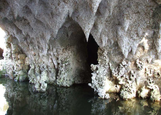
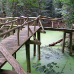
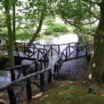
Painshill, the restored crystal grotto. Photo: Painshill Park Trust, 2013.

The following are just a few personal observations during these two days.

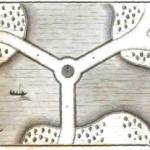
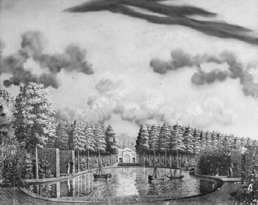
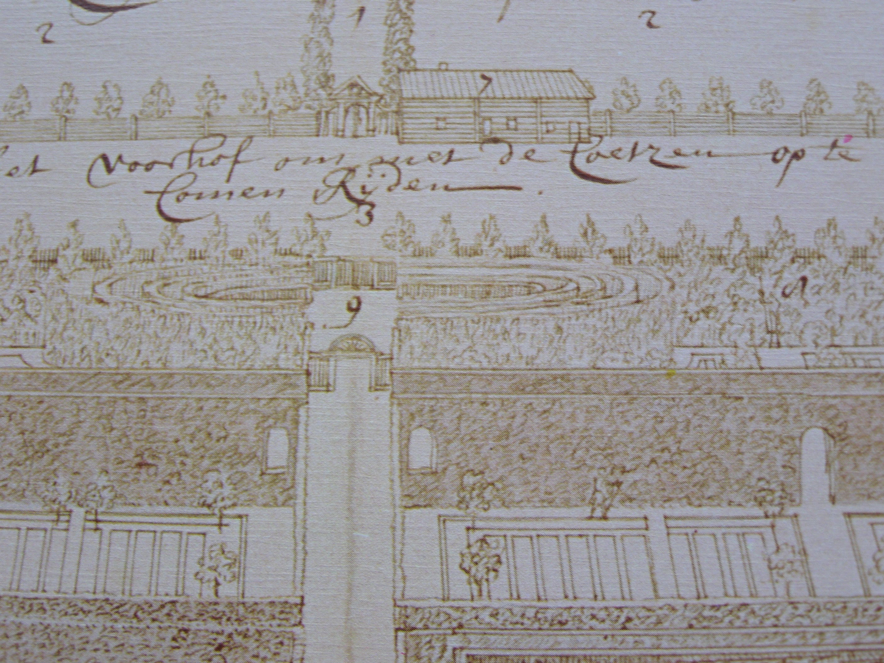
Mount Edgcumbe garden building vs. the Bidloo garden in Moscow.
Bidloo garden viewRichard Hewlings showed a picture of an 18th century drawing of a garden building at Mount Edgcumbe (near Plymouth). I don’t have it here, but the most important feature of that picture for me was not the building, but the planting of evergreens surrounding it. That immediately brought to mind the drawing on the left, by and of the garden of the Dutch physician Nicolaas Bidloo, near Moscow (see this previous post).
I think the author of the Mount Edgcumbe drawing was called Prudeau Edmund Prideaux (1693-1745), drawing this around 1727 -according to my notes. I hope this drawing is published somewhere, but I didn’t get that impression at the time. So you’ll just have to take my word for it, but if we do away with the fence in the Bidloo drawing and replace the gardener with the Mount Edgcumbe garden building, the resemblances are remarkable. Bidloo‘s drawing dates from the same period (late 1720s), but was never published till the 1970s. Could he have known the Mount Edgcumbe drawing? Or could the circular area -with or without building- surrounded by a thick planting of evergreens have been the norm at the time?

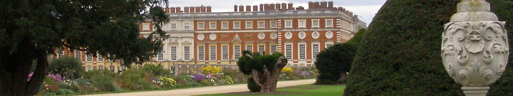
Stourhead vs Rievaulx Terrace .
Oliver Cox was invited to talk about his view on the attempts to explain Stourhead‘s iconography over the last decades. Like he did earlier in his article in the GHS journal, Cox ‘condemned’ (nicely) academic disregard for contemporary garden visitors’ descriptions. 1Oliver Cox, ‘A mistaken iconography? Eighteenth-century visitor accounts of Stourhead’, in Garden History 40:1 (2012), p.98-116. These visitors never gave any indication of being aware of even the existence of an iconographic program in the garden of Stourhead, let alone that they made attempts to explain it.
Michael Symes, in another context, used the term ‘iconographic phallacy’ to describe how an intended iconography, deliberatly used by the garden owner and/or garden designer, could sometimes not land with the garden’s visitors and therefore remain largely unnoticed. It doesn’t mean the iconography wasn’t there, it just wasn’t picked up.
But that is of course the usual slippery slope iconographical explanations -without solid backing from contemporary sources- have always had to deal with, a situation that will always have to be taken into account. In that sense Cox’s sceptic approach can only be applauded.

But one argument Cox uses to underline his point strikes me as odd. He mentions that in c1818 a guide to the garden of Stourhead was published, in which the entrance was on a totally different place than where modern ‘academics’ thought it had been. The routing of the garden was different, therefore the garden buildings were not approached in the careful order suggested by the advocates of different iconographical explanations -who relied on this particular routing. 2Oliver Cox, op.cit., p.104.
Cox combines this with the lack of iconographic references in visitors’ accounts, to question modern ‘academia’ in their attempts to impose an iconography on Stourhead gardens.
My objection would be that this c1818 guide was published over half a century after most garden buildings at Stourhead had been built, or at least conceived. It is not impossible that two generations later, the garden was conceived in a different light and that certain changes in taste were followed by adaptations in the layout. I don’t see how this entrance being on another location then could say anything worthwhile about the situation 50 to 60 years earlier, without evidence supporting the fact that the entrance had been on that location all along. As that evidence is not supplied, I can’t help but conclude that Cox is replacing one ‘slippery slope’ by another.

Speaking of slopes: it is here where Rievaulx Terrace comes into play, as far as I am concerned. Just half an hour earlier, dr Patrick Eyres was speaking at  the conference. He mentioned, that where the approach to Rievaulx Terrace in the 1770s focussed on the views at the low lying ruined abby from the terrace, that situation seems to have changed by 1820. Then, at least one account heralds the view at Rievaulx from the valley the abbey was built in. Turner’s 1836 watercolor also uses that lower view point. Could this same movement have happened at Stourhead? And thus caused the entrance to be relocated to a position more suitable to the early 19th century taste?

This doesn’t necessarily mean that the overall approach to British gardens -and the elements in them- changed to such an extend between 1760 and 1820, that in some cases (quite literally) the approach or entrance itself needed to be changed. There are practical reasons to think of in the case of Rievaulx Terrace: maybe the views from above were overgrown and not discernable anymore. But this is a subject that is worthwhile investigating.

Tea house activities
I’d like to end this on a much lighter note. As we’re on ‘slippery slopes’ anyway, I’ll descend a little bit further to embrace another garden building ‘association’. While summarizing one of the lectures, conference chairman Tim Richardson said in a by-line: “There’s not much else one can do in an open structure like a Chinese tea house, than, well… have tea.” From a Western viewpoint, he is probably right. But I’d recommend a visit to the British Museum’s current Shunga exposition exhibition, to see how these buildings could also be used -in their original context, both in Japan and China (and maybe provided one’s teahouse has a second floor).
See the video for a ‘curators introduction’ to this exhibition, the caption image is a tea house scene already.


Enhanced by Zemanta

Footnotes

Footnotes
1 Oliver Cox, ‘A mistaken iconography? Eighteenth-century visitor accounts of Stourhead’, in Garden History 40:1 (2012), p.98-116.
2 Oliver Cox, op.cit., p.104.

Swimming in the garden

Sport and recreation have always been an important part of bigger gardens and garden culture. Playing bowls, cricket, croquet, tennis, going out boating on the pond, even winter ‘games’ took place in the (larger) garden area.
All activities mentioned above come with their own set of materials or equipment to be able to recreate. The proper environment had also to be there: a pond for the boating, or a purpose-built lawn for the bowls game -the bowling green. Cricketers may have been less fussy about the quality of the grass than bowlers, provided it was kept short and there was enough space to bat (and catch) the ball.

Here I refer to an example of a type of recreation that is less obvious in a garden, and apparently doesn’t necessarily need any equipment at all: swimming. Huys ten Donck sloot zwemmenAt Huys ten Donck, it seems, the only thing they needed in 1766 was a ditch. This note was made in relation to swimming in june 1766 (click the image to enlarge). It is in Dutch, of course, and roughly translates as: “and 2 barges of sand for the ditch mylord swims in”. 1Stadsarchief Rotterdam, toegang 30 (archief Huys ten Donck), inv.nr. 1326. The note was written by head servant Pieter de Vos, listing costs made from March 1766 onwards (“rekenijng van de arrebeijders”). The reference to swimming is listed under June (“ijunius”) and reads: “nog 2 schute zant voer de sloot daer mijnheer in zwemt 0-12-0”.

The sand was probably used to keep the water from getting murky, as smaller soil particles would have been whirled up by ‘mylord’ Cornelis Groeninx van Zoelen’s swimming movements. The sand should have also kept waterplants from growing in the designated swimming water.
Cornelis Groeninx van Zoelen (1740-1791) was at the time in the process of changing the layout of his garden, at least partly laying out the garden in the landscape style in 1769. It is unclear whether that particular part of the redesigning process had already started in 1766. 2Heimerick M.J. Tromp, De Nederlandse Landschapsstijl in de Achttiende Eeuw (Leiden 2012), p233.

Of course, there are developments here as well, too far and wide to be described here. The swimming area was often accompanied by a bath house, even during the time of Huys ten Donck‘s simple solution.
But also later on, as this example shows: follow this link to find a photo of the old swimming pool at De Wildenborch, near Vorden, in the east of the country. This part of the garden dates back to the 1930s, according to the description of the garden in the national register of monuments. This swimming pool or ‘petit canal’ may have been a former ditch, transformed into a rectangular swimming pool with a simple structure at one end, containing two dressing rooms. Even a simple structure like that does not seem to have been present at Huys ten Donck in 1766 -at least: no description of a bath house or similar structure has survived.

Footnotes

Footnotes
1 Stadsarchief Rotterdam, toegang 30 (archief Huys ten Donck), inv.nr. 1326. The note was written by head servant Pieter de Vos, listing costs made from March 1766 onwards (“rekenijng van de arrebeijders”). The reference to swimming is listed under June (“ijunius”) and reads: “nog 2 schute zant voer de sloot daer mijnheer in zwemt 0-12-0”.
2 Heimerick M.J. Tromp, De Nederlandse Landschapsstijl in de Achttiende Eeuw (Leiden 2012), p233.
Summary

An easily overlooked reference from 1766 indicates that the owner of Huys ten Donck (Ridderkerk) liked to swim in a ditch in his garden. No evidence of a bath house or similar structure has survived.

Continue reading

A triple bridge at Den Alerdinck

Not necessarily as a result of my previous post about the Triple Bridges map, a new addition to the map is made public in this post. Above that we take a look at different typologies of these bridges that seem to present themselves, with the preliminary conclusion that these differences seem to be regionally determined.

Bridge at Den Alerdinck, circa 1800
This weekend I was talking to dr Lucia Albers, who mentioned to me that there was a triple bridge at Den Alerdinck, a garden to the south east of Zwolle. Although the bridge itself is not mentioned there, her publication about the architect of the landscape garden at Den Alerdinck dates back exactly 20 years. 1Albers, dr. L.H., ‘Wie was de architekt van De Alerdink bij Heino’, in Cascade  2 (1993), nr.2, pages 13-18.

1812-1822 KMP den Alerdinck

Den Alerdinck, detail of the survey map of 1812-1822.
Source: watwaswaar.nl

The website of Den Alerdinck mentions Johan David Zocher (1763-1817) as the designer of the landscape garden. 2A design of this garden does not exist. Albers noted that this name is indeed mentioned in the family that owned the estate for a long time, but she has her doubts. She presented several other possible architects for this garden, notably G.A. Blum(e) (1765-1827). Both Zocher and Blum(e) are also named as the architects that drew a map of Fraeylemaborg, possibly as early as 1802. There is also a triple bridge in that garden. They were of the same generation, both of German descent, and it seems it is not easy to distinguish between the two (even when drawings exist).

Albers managed to reduce the design period of this landscape garden at Den Alerdinck to 1797-1807, regardless of who the architect was. This fits quite well in with what we think we know about Blum(e), who worked in this part of the Netherlands more often. 3A report by Bureau N0.0rdpeil about Fraeylemaborg apperently already mentioned the fact that those owners had ties with the elite in Zwolle (see this comment by Jan Holwerda). Den Alerdinck’s owner Bernardus J. van Sonsbeeck belonged to this Zwolle elite, as did other estate owners who employed Blum(e). But Zocher worked throughout the whole country, so he cannot be ruled out.

Different types
While the triple bridge portfolio is building up, it becomes clear there are at least two different types. The bridges found in the Netherlands are all of the more simple type: three bridges coming together in the center, with no specific building or design on this meeting of paths.

1812 - 1822 KMP den Alerdinck detail1817 Wetteren Caledonian Horticultural Society

The more southern gardens – those represented in Le Rouge, but also the garden in Wetteren (Belgium) – have a more elaborate meeting point (image right). There it is not just a location where parts of the bridge meet, it is embellished with a circular structure. In the Belgian garden there is even a Chinese building created on top of the center of the bridge (this may have also been the case in the Le Rouge examples, but there we only have the view from above). This center seems to have been more a place to dwell in southern gardens, than a section to pass, as is the case in the Dutch types (image left).

It is way too soon to conclude anything about the origins and the different typologies of the Triple Bridge, but I did want to point out that the northern types are up till now consistently different than the southern ones. Whether that is just a regional thing, or a question of taste or education, remains to be seen.


Enhanced by Zemanta

Footnotes

Footnotes
1 Albers, dr. L.H., ‘Wie was de architekt van De Alerdink bij Heino’, in Cascade  2 (1993), nr.2, pages 13-18.
2 A design of this garden does not exist.
3 A report by Bureau N0.0rdpeil about Fraeylemaborg apperently already mentioned the fact that those owners had ties with the elite in Zwolle (see this comment by Jan Holwerda). Den Alerdinck’s owner Bernardus J. van Sonsbeeck belonged to this Zwolle elite, as did other estate owners who employed Blum(e).
Summary

Den Alerdinck is the next northern example of the triple bridge. It was designed c1800, possibly by G.A. Blum(e) (1765-1827).

Continue reading

Triple bridges, a new map

Just a short note that another map has been added to the collection. This time it does not focus on gardens in a region, but on a certain type of garden feature: the triple bridge. Also known in French as Triple pont or Pont triangulaire, and in Dutch as Driepuntsbrug, it was long supposed to be a feature typical for 19th century garden design in the Dutch northern provinces.
Research by TuinTerTijd has shown that examples from early in the century can be found in what is now Belgium (but belonged to the United Provinces at the time of creation). Ultimately, even earlier examples turned up: in and around Paris during the 1780s (that’s where the French terms come from).

This is the type of bridge we are looking for:

I’m just collecting them on a map, to make their appearance in time and location more clear. And, OK: I found the Parc de Bagatelle one myself… To find out what the different colours mean, click here. With your help the map will be updated regularly (I hope), so please let me know when you have a new addition (executed or not).

Driepuntsbruggen / triple bridges / trois ponts View as larger map.

Armchair garden archaeology

In dry and warm summers like these, underlying structures often shine through the otherwise opaque green surface of garden lawns. Robert Greening already knew that in 1752, when he advised that the rich soil of the former parterres in the north garden of Wimpole Hall should be dispersed over and mixed with the rest of the soil as much as possible, before he grassed it over. 1See: M. Laird, The Flowering of the Landscape Garden; English Pleasure Grounds 1720-1800 (Philadelphia 1999), page 120.. Also used in my article on the aesthetics of lawns in 2002: Van der Eijk, H.; ‘Van bloemenweide tot “melancholy lawn”: oorspronkelijke ideaalbeelden als basis voor ontwerp en beheer van gazons in (vroeg-) landschappelijke tuinen.’, Cascade 11 (2002), nr 2, p.25-44 [pdf] (in Dutch). Gawthorpe Hall parterreHe also advised to dig out foundations of former buildings to a good depth, “else in the Summer the Grass will burn & shew where each wall was.

Luckily not everybody heeded his words, otherwise we would have missed out on many views that have been posted in the UK the past week. One example from Gawthorpe Hall is striking because it also gave a photo from the situation that was shining through (via @NTGawthorpe ).

I have not yet seen any accounts coming in from the Netherlands. I can’t imagine there are no examples to be found here, our summer has been quite dry over the past month.

Anybody?

Enhanced by Zemanta

Footnotes

Footnotes
1 See: M. Laird, The Flowering of the Landscape Garden; English Pleasure Grounds 1720-1800 (Philadelphia 1999), page 120.. Also used in my article on the aesthetics of lawns in 2002: Van der Eijk, H.; ‘Van bloemenweide tot “melancholy lawn”: oorspronkelijke ideaalbeelden als basis voor ontwerp en beheer van gazons in (vroeg-) landschappelijke tuinen.’, Cascade 11 (2002), nr 2, p.25-44 [pdf] (in Dutch).
Summary

Dry conditions ake it easier for garden archaeologists and historians to see what history is lurking underneath the otherwise opaque green surfce of garden lawns.

Continue reading

Broderies (Le Nôtre) at Sceaux restored

France this year celebrates the 400th birth year of one of the most influential garden architects ever: André le Nôtre (1613-1700). In light of that anniversary, parts of his designs at Parc de Sceaux are being restored. Maybe recreated is a better term for the layout of the parterres de broderie that is currently going on. The restoration goes back to the situation after Le Nôtre’s second round at Sceaux in the 1680s.

The Domaine de Sceaux simultaneously set up an entire program of lectures and exhibitions around Le Nôtre, his work in general and at Sceaux in particular. The details of the restoration and surrounding program can be found here (in French).
An information package (for the press), with designs and the evolution of the parterres since the 17th century, can be found here. 1Including a page showing ‘Evolution des parterres de Sceaux sur 400 ans‘, forgetting that we are now celebrating Le Nôtre’s birth 400 years ago. Work on the parterres could only have started after 1670, a ‘mere’ 343 years ago…

Sceaux development parterres

Box / Buxus / Buis
What strikes me is the fact that while in some big gardens in Holland the box plantations are being replaced by plants that do not suffer from the diseases box has, the parterres de broderie at Parc de Sceaux are planted with 6 km of exactly that plant. I can understand that when one restores a garden layout in the year of the architect’s anniversary, one is inclined to use the sorts and species we know that architect originally used. But the way box diseases are spreading over Europe, this may not turn out to be the most prudent decision.

Pickets
Another interesting difference in approach is the fact that at Sceaux no corten steel strips or other materials are used to help keep the lines of the parterres intact. At Het Loo corten steel strips now do the work that was previously done by plastic strips (dating from the reconstruction over 30 years ago). At Assumburg they used a different approach, it seems. But neither one of them created their parterres with the simple, probably much cheaper and hopefully effective method that this video of the work at Sceaux shows.

[Edit July 24, 2013: @LeNostre (the Twitter-handle of André le Nôtre) pointed out to me that at Sceaux metal strips are actually used to form the volutes. Thus rendering the above section pointless. I could have known, because it is mentioned on page 12 of the presentation I myself refer to above.]

It will be interesting to check in again in about ten years from now and see how the lines of the parterres at Het Loo and at Parc de Sceaux, both (re)planted in the spring of 2013, developped. Keeping in mind that at Het Loo, no box is used, but Ilex crenata; and that Sceaux is a public park used for daily recreation (Het Loo is a museum garden).


Enhanced by Zemanta

Footnotes

Footnotes
1 Including a page showing ‘Evolution des parterres de Sceaux sur 400 ans‘, forgetting that we are now celebrating Le Nôtre’s birth 400 years ago. Work on the parterres could only have started after 1670, a ‘mere’ 343 years ago…
Summary

André le Nôtre’s parterres de broderie are being reconstructed at Parc de Sceaux, as a reminder that the architect was born 400 years ago. The parterres are lined with box, and the whole approach seems to be different than the one use in reconstrutions in Holland.

Continue reading

Hochwasser in the Elbe gardens

The floods in large portions of Germany have caused lots of trouble for the everyday life of many citizens, who sometimes just  recovered from the floods in previous years. Floods in the Elbe region are nothing new, there were floods in 2006 and there was the ‘flood of the century’ in 2002. But this year it seems to be really bad, many record levels have been broken.

Along the borders of the river Elbe, at least three major historical gardens have also been hit by floodwaters: Schloss Pillnitz, the Grossen Garten in Dresden and -most recently- Wörlitz.
Wörlitz seems to have been less affected of the three, their website states that the garden can be visited. Be that as it may, the still increasing photoseries by Ludwig Trauzettel shows how much effort the park management, police, fire department, divers and volunteers have put in the protection of the park’s vital infrastructure. And how some bridges still disappeared under the water they were supposed to cross. The series is a stunning eyewitness account of a potentially devastating event.

As we know, not all gardens have equally good chroniclers. The Grossen Garten did flood, but I have not found as many images. The ones that are there, bring the message across, though.
Flooded Grossen Garten in Dresden

Schloss Pillnitz had an exhibiton last year, remembering the 10-year anniversary of the 2002 flood ‘of the century’. So the images that presented themselves last week and over the weekend must have been very familiar:
A flooded court yard at Schloss Pillnitz - foto DPA
At Pillnitz several events  in the upcoming weeks have been cancelled. And that is where, besides all the damage to plantations and infrastructure, things start to hurt. Tourism and paid events are now an important part of the economy of these gardens and palaces. Without that, they cannot survive. Certainly not when the damage of the previous flood had only recently been repaired.

I visited Pillnitz last year and I sure hope this time the damage is limited.


Enhanced by Zemanta

Overlooked evergreens

The use of evergreens is widespread in the history of gardening. But the way they are represented on maps is not always clear. Or rather, they are not always shown on maps, while we know from other contemporary sources that they were there.
Two Dutch examples:
HtD_Zeuner

One example is the garden of Huys ten Donck, where we know from a glass painting (or ‘verre eglomisé‘) by Jonas Zeuner that one of the ponds was bordered by a small forest of evergreens. The painting is dated ca 1781, as is the map of Huys ten Donck by two surveyors called Maan en Harte. But here we see no clear indication of the evergreens being planted there. Did we not have the garden view by Zeuner, we wouldn’t have had a clue.

HtD_Maan_en_Harte-detail

Huys ten Donck, detail of a map by Cornelis Willem Maan and Pieter Harte, ca 1781. The red arrow indicates the line of view of the Zeuner painting.

The same goes for the garden of the Dutch physician Nicolaas Bidloo, created along the borders of the Yauza (or Jauza) river near Moscow in the first decades of the 18th century. Bidloo himself drew the garden plan, birds-eye view and views within the garden, probably between 1725 and 1730. The whole setup seems to indicate that he wanted these drawings to be published, but that never happened. 1See David Willemse (introd.), The unknown drawings of Nicholas Bidloo, Director of the first hospital in Russia, Voorburg (1975).

Bidloo garden viewBidloo garden plan -detailOne of the garden views (above left) shows a circular space, marked with the number 9, surrounded by a fence and evergreens. When we look at the garden plan (above right), we see the same circular area with the same number 9, but no indication whatsoever that it is surrounded by trees, let alone by evergreens.

The strange thing is that in this case even the birds-eye view (below -click the image for a larger view) does not show there are evergreens planted here. The only thing confirming the garden view, is the legend on the right side of the garden plan, where it says under number 9: “A circular space surrounded by a beautiful fence, and very high pine and lime trees. A thick forest one can walk around.” 2“9. Een Rond, omzet met een moij hek, en grote denne & linde bomen. Een digt bosch dat men rondom gaan kan.”
Bidloo garden birds-eye detail

So the only evidence of what this part of the Bidloo garden looked like, comes from the garden drawing, and the legend on the garden plan. Both these features are rare, very rare. In any case they are much less available than the maps and garden plans we garden historians usually have at our disposal, and on which we base many of our conclusions about the actual layout and contents of a garden.

In the case of both Bidloo‘s garden near Moscow and the garden of Huys ten Donck, we would not have known about these evergreens if we only had the garden plans at hand. It begs the question how many evergreen plantations we have inadvertedly overlooked in our investigations…

Enhanced by Zemanta

Footnotes

Footnotes
1 See David Willemse (introd.), The unknown drawings of Nicholas Bidloo, Director of the first hospital in Russia, Voorburg (1975).
2 “9. Een Rond, omzet met een moij hek, en grote denne & linde bomen. Een digt bosch dat men rondom gaan kan.”
Summary

Drawings showing garden scenes often reveal the presense of evergreen plantations, while these are not visible on maps or birds-eye views of the same garden (sometimes by the same artist). As we have much more maps and plans at our disposal – as a vital source – I now wonder how many evergeen plantations of significance we miss during our research.

Continue reading