Three weeks ago I visited the marvelous garden of Weldam, which I’ll discuss another time. After that I revisited a small wooded area nearby, where I had seen something interesting earlier. In October 2008 I stumbled upon a small elevation or hill at the edge of the woods. I immediately recognised it as man-made and probably part of a park layout, but couldn’t link it to an estate or garden. Somewhat later on that trip I passed the house of Wegdam, but couldn’t piece the two together.
-
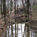
- The small ‘hill’ seen over the water.
-
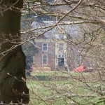
- The front door of Wegdam house seen from the top of the ‘hill’.
-
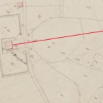
- Central axis leading from Wegdam, with location indicated on the survey from 1832.
-
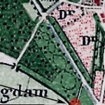
- Map dated 1889 with a ‘new’ layout near the ‘hill’.
-
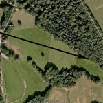
- Central axis in aerial view.
-
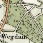
- Map dated 1929 still not showing the elevation in the landscape.
Photos by HvdE (click images to see larger version). Maps from watwaswaar.nl, with adaptations by HvdE. The layout of Wegdam was right on the edge of many older maps, that is the reason why some of the maps above show only part of that layout.
My recent visit taught me why: a visual relation between hill and house is only possible when the trees have no leaves. Trees were just budding in the beginning of April, and I could now spot Wegdam‘s front door from the top of the hill (see my badly focussed photo).
The difficult part in linking both was that the landscape garden at Wegdam has a visual axis that slightly bends to the right. I took a photo from in front of the house and completely mistook the visual axis for the central axis, although I tried to compensate. The elevation is hidden in the woods to the left of this visual axis. But it appears to be exactly at the end of the central axis starting from the front door. This view is supported by careful examination of the maps, although they have not shown this feature until very recently. 1The (1 : 25.000) topographical map of 1989 is the first map I have seen on which the small elevation is indicated.
Having established that Wegdam and the elavation belong to each other, the questions “what was it for?” and “how old is it?” immediately popped up. Without exhaustive research the answer to both questions must be: not certain, but I’ll give it a shot.
Use.
The elevation must have been visible from the main house, but would certainly have been more noticeable with an eye-catcher placed on it. Far from the house, seen from the Oude Needseweg, the hill (and anything adorning it) is reflected in the still water surface of a rectangular ditch or pond. 2If common practise is followed here, the elevation was made with the soil dug out to create the pond. The hill must have had some kind of pavilion on it from which the surrounding landscape could be seen. It could have served as a resting place as well: halfway a walk over the winding paths in the park a short climb opened a vista towards the house where the walk had begun. A belvedere is the most logical use this feature could have had.
Age.
If we take the maps at face value, the hill must have been created between 1846 and 1889, together with the layout of the winding paths on what in 1832 was heathland alongside the Oude Needseweg. The ditch / pond between that road and the hill probably dates from the same period, although it was initially drawn as a road. During this period the small circular pond in the central axis near the house was also created. 3These ‘waterworks’ were probably necessary to improve the soil of the heathland, and make a garden layout possible.
A change in ownership -albeit by marriage of the last heiress- might have inspired a new layout. Wegdam had been in hands of the Van Coeverden family for centuries, but was owned by members of the Amsterdam family Meyjes between 1849 and 1897. It is possible they decided to make a more elaborate layout around what up till then seems to have been a luxury farm.
This small hill and pond seem to be the only relics of the layout in the woods. The paths have disappeared under a thick layer of leaves. But it would be great to find out more about this place. If only because creating such a belvedere and mirror pond seems rather old fashioned for the period…
To be continued, I am sure.
Footnotes
| ↑1 | The (1 : 25.000) topographical map of 1989 is the first map I have seen on which the small elevation is indicated. |
|---|---|
| ↑2 | If common practise is followed here, the elevation was made with the soil dug out to create the pond. |
| ↑3 | These ‘waterworks’ were probably necessary to improve the soil of the heathland, and make a garden layout possible. |

