Sometimes finding similarities between garden designs is just a matter of coincidence, or luck. Despite that, it always results in a feeling of accomplishment which is deserved nor appropiate. It also tends to lead to more questions than answers, which is nice, but not very helpful. This is such a case.
Browsing through one of last year’s more eye-catching books, I stumbled upon a maze I knew I’d seen before -or a slight variation to the design. 1Katrin Schröder: ‘Englische Parthien’ and foreign trees- The ‘natural taste’ in the Frederician garden arts of Prussia; in: Prussian Gardens in Europe. 300 Years of Garden History. Stiftung Preussische Schlösser und Gärten Berlin-Brandenburg (SPSG) 2007, pp. 34-39.
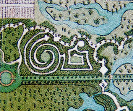
The Sanssouci maze. Detail of a -not executed- part of a remodelling plan made around 1775. SPSG plan collection 11790 (photo from book in note 1). The palace -and the north- is to the right. The image is rotated 180 degrees, which is why all trees are depicted upside down.
This Prussian example of a combined circular and rectangular maze reminded me of a similar maze I saw a short while ago, when I read about a former maze on the isle of Texel, in the upper northern parts of The Netherlands. 2The current owner, Staatsbosbeheer, announced a revitalisation of the Doolhof (the Dutch name for a maze and, though the maze itself has gone, still the name for the road running past it). It soon became clear that by revitalisation Staatsbosbeheer meant refurbishing the paths and adding some benches and more attractive plants to the worn-out bush the Doolhof had become. 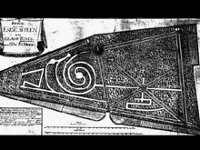 I managed to find this terrible image of a plan, which -according to its source– should date from around 1790.
These mazes are not identical, but despite the differences between them, they are remarkably similar. Both have a circular maze with a -slightly crooked- rectangular appendix; but the Texel maze has only one center, where the one proposed for Sanssouci seems to have two.
Both circular mazes are made up of two paths, spiralling outwards from the center of the maze -or rather: inward to the center of the maze.
They both have one path leading from the center that’s ending in a dead end; although the Texel one has a way out from there, while the Sanssouci maze forces you to go all the way back to the center and try the other path.
The Texel design made before or after 1786?
Depending on which source one chooses to use, the Texel design was made before between 1764 and 1786 (for Cornelis Roepel) or between 1786 and 1794 (for Arie Kikkert). 3The latter period is also mentioned in a recent publication on mazes and labyrinths: Fons Schaefers and Anne Miecke Backer, Doolhoven & Labyrinten in Nederland, Uitgeverij De Hef Publishers, 2007, p. 44 (under the alternative name: ‘Het Bosje’). I believe the maze as shown here might date from before 1786, because of the name used on the plan. The small area has had an impressive amount of names in the past. “Engelsteen” is the name used on the plan from ±1790. An alternative was “Engelse Steen” (“English Stone”). Both names refer to a local belief that the rocky underground of this elevated plot of land was part of one huge stony slab, which supposedly connected Texel to England underneath the North Sea. In fact it is an isolated sediment, created during one of the ice-ages. Today it is simply known as ‘Doolhof‘ or ‘Het Bosje‘ (‘The [small] forest’). 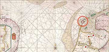
Part of the North Sea, with Texel in the circle on the right.
The Rede van Texel (‘road’ or ‘anchorage’) was situated to the east of the island.
One source is very elaborate about Arie Kikkert creating the maze, refurbishing the place with clipped hedges and summerhouses with benches and mural paintings. This all supports a creation date of 1786 or later. So that source dates the plan to ±1790. It also says Kikkert renamed his patch of forest into “‘s Lands Welvaartszicht“. 4That name translates roughly as “Prospect of the country’s Prosperity”, probably because from this elevated spot -a whopping 15 meters above sea leavel!- on the island he had a good view at the tradeships from Amsterdam, Hoorn and Enkhuizen docking at the Rede van Texel), waiting for a favourable wind to sail out to the East Indies. And it does not question why the map sports the old name for his property, instead of the new one he himself invented? I believe the plan was made before 1786. One source even specifies this and dates it to the last months of 1774, but does not give any supporting evidence for that claim. 5Doolhof: Tegen de Hoge Berg ligt een interressant loofbosje dat de Doolhof wordt genoemd. Het werd eind 1774 aangelegd door Cornelis Roepel of Ruepel, commissaris van de Amsterdamse Admiraliteit, die daarmee een lusthof voor zichzelf en zijn familie wilde creëren. De trap op het hoogste punt (15 meter boven de zeespiegel) van het bosje wordt ook wel de Zeven Pannekoeken genoemd. Het doolhof, zo genoemd naar de labyrintische dooreengevlochte slingerpaden valt onder beheer van de Stichting Natuurmonumenten en Staatsbosbeheer.
Relationship between the two desings?
Regardless of its precise dating, the plan for the Texel maze has been created approximately the same time or shortly after the Sanssouci remodelling plan was drawn. Which does raise the question how and why these two almost simultaneous designs can bear so much similarities? They are separated by almost 600 kilometers of land and sea and situated in separate countries. The Sanssouci design was made for a Prussian king, the Texel design for a local buff, working in or highly dependant of a country whose political and economical role was diminishing sharply -and with no known cultural relations whatsoever.
If the design was indeed made for Cornelis Roepel, there is a chance he may have had contacts with important garden owners with connections or ideas. Roepel worked for the Admiraliteit van Amsterdam (Amsterdam Admiralty), which was one of the most powerful and influential organisations in The Netherlands. And although Roepel was situated in what we now consider as an outpost of the country, in his age this was the point where tradeships from all over the world anchored before sailing through to Amsterdam -or vice versa.
The design has a familiar feel to it, but I still haven’t figured out how these designs ended up looking like each other as they do. Both gardens may have had the same designer, but it seems more likely both designs refer to another example. The only example I know that comes close to these two, is a design published by Dezallier d’Argenville. Although that design was highly popular and used in several gardens in The Netherlands, it must have been oldfashioned by the time the Texel and Sanssouci designs were made. Besides that, it only accounts for the paths, spiralling out from the center of the maze. None of the other characteristics of the Sanssouci and Texel mazes are present.
I doubt these mazes have had the same designer. But there surely is one combined source for both designs?
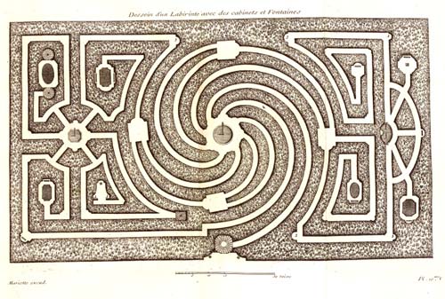
‘Dessein d’un Labirinthe avec des cabinets et des Fontaines’, from: Antione Joseph Dézallier d’Argenville, La Théorie et Pratique du Jardinage, Paris, 1709.
Footnotes
| ↑1 | Katrin Schröder: ‘Englische Parthien’ and foreign trees- The ‘natural taste’ in the Frederician garden arts of Prussia; in: Prussian Gardens in Europe. 300 Years of Garden History. Stiftung Preussische Schlösser und Gärten Berlin-Brandenburg (SPSG) 2007, pp. 34-39. |
|---|---|
| ↑2 | The current owner, Staatsbosbeheer, announced a revitalisation of the Doolhof (the Dutch name for a maze and, though the maze itself has gone, still the name for the road running past it). It soon became clear that by revitalisation Staatsbosbeheer meant refurbishing the paths and adding some benches and more attractive plants to the worn-out bush the Doolhof had become. |
| ↑3 | The latter period is also mentioned in a recent publication on mazes and labyrinths: Fons Schaefers and Anne Miecke Backer, Doolhoven & Labyrinten in Nederland, Uitgeverij De Hef Publishers, 2007, p. 44 (under the alternative name: ‘Het Bosje’). |
| ↑4 | That name translates roughly as “Prospect of the country’s Prosperity”, probably because from this elevated spot -a whopping 15 meters above sea leavel!- on the island he had a good view at the tradeships from Amsterdam, Hoorn and Enkhuizen docking at the Rede van Texel), waiting for a favourable wind to sail out to the East Indies. |
| ↑5 | Doolhof: Tegen de Hoge Berg ligt een interressant loofbosje dat de Doolhof wordt genoemd. Het werd eind 1774 aangelegd door Cornelis Roepel of Ruepel, commissaris van de Amsterdamse Admiraliteit, die daarmee een lusthof voor zichzelf en zijn familie wilde creëren. De trap op het hoogste punt (15 meter boven de zeespiegel) van het bosje wordt ook wel de Zeven Pannekoeken genoemd. Het doolhof, zo genoemd naar de labyrintische dooreengevlochte slingerpaden valt onder beheer van de Stichting Natuurmonumenten en Staatsbosbeheer. |


Henk,
alweer erg interessant!!
Ik meen ergens anders nog iets over buitenplaats op Texel te hebben gelezen ; geen idee meer waar. Maar stond niet iets over doolhof en al helemaal geen kaart. Het originaal van die kaart of een betere kopie zou ook mooi zijn.
Groet
Jan
Dank, Jan! Het zou heel mooi zijn als je die informatie nog boven tafel kunt krijgen. Zoveel buitenplaatsen kunnen er op Texel niet zijn geweest, lijkt me (deze opmerking bevestigt waarschijnlijk alleen maar dat dit een Terra Incognita voor me is).
Ik moet inderdaad op zoek naar een betere versie van die kaart van Engelsteen, maar moet op dit moment blij zijn dat ik deze in ieder geval heb gevonden. Vooralsnog heb ik geen idee waar het origineel zich bevindt, maar die zoektocht moet ook nog beginnen.