A lot has been said about the recent digitization of a very large map of Elswout (dated 1812). The past few weeks the archive where the map is stored, the company doing the work, and 1 or 2 blogs have all revelled over the stunning results. Last Monday a special presentation was held at the Noord-Hollands Archief, where the process, the map and previously hard to detect details on it, were discussed.
An avenue of alternating trees
Unfortunately I could not be there, but I did of course have a look at the map in its newly available format. And I was not disappointed. Besides all kinds of interesting details, I almost immediately ‘discovered’ another mixed avenue lined by deciduous and evergreen trees. 1Please see my previous posts about the subject. I found three (all) types of mixing trees in avenues: deciduous-evergreens; mixed deciduous and mixed evergreens.
There are two other locations in the park of Elswout where this type of mixed planting can be seen, in a way I have also seen used in other contemporary gardens by other architects. More about that in a separate post.
An avenue planted with two different types of trees, planted in an alternating fashion prolongs the central axis that runs over the bridge from the house (larger detail here):
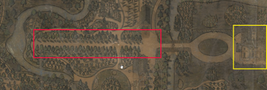
Elswout, with the house (yellow rectangle) and the avenue (red rectangle). Detail of a map by Hendrik van Zutphen, 1812.
The map(s) and the garden design
First of all, there are two versions of this map, one of them located on a thusfar unknown location and only available as a relatively small print in a publication. This second map slightly differs from the one that is now scanned, but even from the small print it is clear that the avenue is the same on both maps.
The surveyor who drew these maps in 1812, Hendrik van Zutphen, also made some smaller maps of details in the immediate vicinity of Elswout. If he made a detailed map of the area south of the house (where the avenue is), it has not survived (or surfaced).
Secondly, the map shows in great detail the results of the by then 30 year old design (from 1781 onwards) by Johann Georg Michael (1738-1800). We see his trademark elements of the landscape style wedged within the remnants of the geometrical, old garden. Michael made the Elswout design for Jacob Boreel (1746-1794), owner of Elswout since 1781. He was the youngest son of Jacob Boreel Jansz (1711-1778), for whom Michael had worked at Beeckestijn in the 1760s -the first garden design in Holland for the young German architect and also the place where he lived for a long time.
The avenue
The garden designs Michael made for the father (Beeckestijn) and for the son (Elswout) both have this type of mixed avenue. In both cases the parts with mixed types of trees cover just a short distance of a much longer avenue / central axis that is for the most part lined by just one type of tree. 2To be clear: it is possible that although the trees are drawn in the same way -and let’s suppose that this are meant to represent deciduous trees, the avenue itself could have consisted of different types of deciduous trees. An example of this is the avenue of mixed deciduous trees on Tottenham Park (see note 1). Because it only distinguishes between evergreens and deciduous trees, in the case of Tottenham Park a map like this wouldn’t have clarified the precise planting as well. Luckily, there the avenue is from a later date and parts of it still exist.
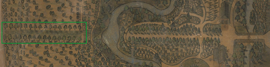
The continuation of the avenue with regular planting: one type of tree (green rectangle). Detail of a map by Hendrik van Zutphen, 1812.
The difference is that at Beeckestijn the mixed avenue is away from the house, at the back end of the garden (but in front of the triumphal arch), while at Elswout it is located near the house, where it is the decorative start of a visual axis that runs way beyond the borders of the garden proper (much further than depicted on these maps), and becomes less embellished as soon as the water is crossed. The design of these two avenues suggest the following arrangement of trees (as I already -presumptuously- concluded above):
evergreen – deciduous – evergreen – deciduous – evergreen – deciduous, etc.
The current situation
I’m not certain how long the mixed avenue existed on this location, but it probably didn’t survive the big changes of the early 1880s. The intention to retain this visual axis in combination with an avenue is quite visible on several reorganistion plans made since the last quarter of the 19th century. There is an avenue on plans made by both L. Springer (plan not executed) and C.E.A. Petzold (partly executed). Both plans are dated 1883, when the second house of Elswout was demolished and replaced by the current house. This type of change to the house may have affected the avenue (by then a design of 100 years old) as well: new house, new avenue.
However: since both designs were hardly executed, and the look I had at several RAF aireal photos made in february 1945 do not give enough information to conclude that an avenue was actually there at the time (at least not between the house and the water, where the mixed avenue was drawn in 1812), it is hard to tell. I should go and have a look at a map of his specific area of Elswout made by G. Bleeker in 1948, whenever I am in the Speciale Collecties at Wageningen UR again. 3Inventory number 28.122.01, a map showing the house and surrounding areas with views to the east and south. The latter specifically concerns the location of our previously mixed avenue.
In 1991, Bureau B+B Stedebouw en Landschapsarchitectuur made another design for the park and if I am not mistaken the young beech trees on this photo from 1998 are planted around the same period.
This current situation disregards the (maybe shortlived) period where an almost typically (and almost equally forgotten) late 18th century garden feature as the avenue of mixed evergreens and deciduous trees occupied the site. It may take a while, but when the beeches need to be replaced, replanting with a mixed avenue is an option: it has been done before.
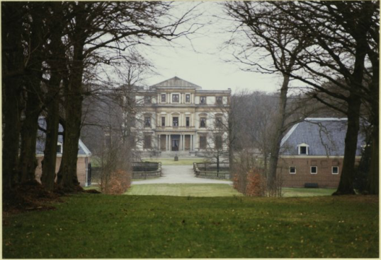
A view at Elswout from the south (Zijweg), showing the avenue lined with older lime trees on the foreground, and young beech trees at the site of the former mixed avenue. Photo in the collection of Noord-Hollands Archief.
Footnotes
| ↑1 | Please see my previous posts about the subject. I found three (all) types of mixing trees in avenues: deciduous-evergreens; mixed deciduous and mixed evergreens. There are two other locations in the park of Elswout where this type of mixed planting can be seen, in a way I have also seen used in other contemporary gardens by other architects. More about that in a separate post. |
|---|---|
| ↑2 | To be clear: it is possible that although the trees are drawn in the same way -and let’s suppose that this are meant to represent deciduous trees, the avenue itself could have consisted of different types of deciduous trees. An example of this is the avenue of mixed deciduous trees on Tottenham Park (see note 1). Because it only distinguishes between evergreens and deciduous trees, in the case of Tottenham Park a map like this wouldn’t have clarified the precise planting as well. Luckily, there the avenue is from a later date and parts of it still exist. |
| ↑3 | Inventory number 28.122.01, a map showing the house and surrounding areas with views to the east and south. The latter specifically concerns the location of our previously mixed avenue. |


And another mixed avenue by the same architect Johann Georg Michael, now at Pyrmont in Germany. It is not a new discovery, just a mixed avenue I overlooked till today.
This particular avenue consisted of two types of deciduous trees: lime (Tillia) and horse chestnut (Aesculus).
That avenue is mentioned on page 109 of Heimerick M.J. Tromp, De Nederlandse Landschapsstijl in de Achttiende Eeuw, Leiden 2012 (‘Tromp 2012’). The description comes from the travel diary of J.F.W. van Spaen van Biljoen, who undertook a trip though Germany in 1783 (a map of this route is shown on Tromp 2012, p107).
http://www.sidestone.com/bookshop/de-nederlandse-landschapsstijl-in-de-achttiende-eeuw
The avenue is described as being very long, starting at the right side of the source, running up to a large circular pond filled with trout and surrounded by flowering shrubs and exotic trees (reference in Tromp 2012, p110, n292; including part of the original text in French).
Bad Pyrmont was (it still is) a spa resort in the center of Germany -hence the source where the avenue started. The architect Michael went there for health reasons in 1778. The work he apparently did there -Van Spaen is very certain that Michael was responsible for at least this part of the layout, although modern garden historians doubt that- was thus probably executed between 1778 and 1783.